


The trails take you through carnivorous areas with picturesque names: Engineer Pass, Cinnamon Pass, Poughkeepsie Gulch, Animas Forks and Capitol City. It was somewhere in these mountains that Alferd Packer, a prospector and guide, decided that the five men traveling with him in the winter of 1874 would taste mighty good in a stew. Though "emergency cannibalism" was all the rage in the West at the time, Packer was eventually arrested and convicted. The sentencing judge allegedly pronounced Packer a "voracious, man-eating sonafabitch" that he would "sentence to hell" if the law allowed it. As it was, Packer served only 18 years for his crimes.

Alferd Packer, who bears a striking resemblance to Charles Manson
The story of Alferd Packer seems incongruous in such an area of beauty. The mountains are filled with creeks, waterfalls, ghost towns and long, sweeping vistas. But it is an appropriate reminder that the mountains...or your prospector guide...may kill you. 
Though the 'official' Alpine Loop is 65 miles long, hundreds of miles of forest roads, jeep and 4x4 trails intersect and are poorly marked, taking you down deadends to places difficult to depart. Steve and I decided to join the Loop in Lake City, Colo., a town of 325 souls just north of the frighteningly steep Slumgullion Pass. Lake City has a long history but it seems to exist now to service the many intent on an Alpine Loop excursion. On a summer weekend (the Alpine Loop season is short, sometimes just over two months), parts of the Loop start to look like Main Street, with people lined up single-file in jeeps, ATVs and 4-wheel drive trucks. Because vehicles with 4-wheels can cruise at 1-mph over craggy, boulder-strewn patches, it is best for bikers not to be behind them. However, getting around an obstacle on a 7-foot-wide trail where one side is a rock face and the other is a 1,000 foot plunge to the mountainside below can be entertaining, in a bad sort of way.
 Different curves on Engineer Pass
Like many life adventures, the Alpine Loop starts out deceptively easy. The first nine miles out of Lake City is on County Road 20, a beautiful dirt road with easy grades, no rocks and plentiful public bathrooms.

At the remnants of the old mining town called Capitol City is the directional sign that sealed our fate for the day.
From this point on, the lovely County Road 20 begins a rather rapid deterioration to areas of both small and large loose rock along narrow trails and switchbacks, some with intimidating dropoffs. I was very happy at this point to be on a 300-lb BMW G450X instead of the much heavier R1200GS. Though the GS could have easily handled these trails, the extra weight would have been extremely challenging and I cringe to think about righting the bike if I went down. After getting an obligatory picture at the Engineer Pass crossing and watching Steve's bike BLOW OVER because of 50-mph winds (the jeepster boys just stood and watched while Steve struggled to right his bike. I guess they didn't want to interrupt his "Zen and the Art of Motorcycle Cursing.")
From there we took random trails to Animas Forks, a fabulous century-old mining ghost town. I don't know how we ended up there as I COULD NOT TEAR MY EYES OFF THE TRAIL and had long stopped looking at maps for fear of plunging off the mountain and dying. The GPS Steve had borrowed kept showing him where we were which didn't matter in the least because we just needed to know where we were going.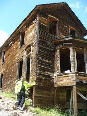
Animas Forks is a particularly impressive place. Because of the low humidity and lack of rot, all the old wooden structures still stand, including a 3-story Victorian home with a large bay window built in 1875 by Tom Walsh, then-owner of the Hope Diamond and founder of the local Camp Bird mine. At Animas Forks, we got our bearings and finished our days' trailriding adventure in Silverton, Colo., home of the famous Durango-Silverton Narrow Gauge Railroad. If you ever have the chance, take the train. It will allow you to sit back and enjoy the scenery instead of constantly worrying about faceplanting into it. It was in Silverton we met the three 30-ish dirt bike guys who told us about their friend careening off the side of the mountain and having to scramble for dear life earlier that morning. Nothing like a side order of cold reality with your burger.

The Durango-Silverton Narrow Gauge. Great fun and no falling.
After our late lunch in Silverton, we decided to take pavement back to Lake City, yet ANOTHER mistake. Argh. Is it possible that the highways that run through Ouray (aka: "Little Switzerland of Colorado") and Gunnison could be even scarier that the trails? Yes, it is, people, yes it is.

Argh.
Several hours later, we were back in Lake City, determined to search for trails that would offer the beauty and the fun without so much physical danger. It was the decision that would lead us to Creede, our next mistake.
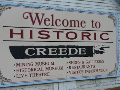

Creede is a gritty, working-class sort of a town, all snugged up in some big craggy rocks. It sits at 8852 feet and has been called the 'silver mining town that would not die.' In fact, there's still a lot of silver in them thar hills, but the price is too low to make extracting it worthwhile. The last mine shut in 1985 leaving the area to eke out a living on government jobs and tourism. Creede is one of those towns where people go to dance to their own drummer or to flat be left alone.

One of the locals, fired up about somethin'
I figured the folks at the local ranger station would surely be able to fill us in on easier local trails and they were quite informative. Their information was WRONG, but they gave quite a lot of it, cheerfully. After purchasing close to $50 worth of maps, the nice retired couple at the desk proceeded to draw highlights all over the map showing the lovely scenic local trails.

It was not until the trip home I saw what they had actually drawn, and then it all made sense.
They told us to take Bachelor Loop, a truly enjoyable forest service road to the trailhead for Rat Creek and from there, they sketched out a series of 'we did them in a jeep last week' roads they promised would be JUST FINE on a motorcycle. These people had quite obviously never been on a bike of any kind. I tend to believe they had never been on these trails, either. There are worse things I could say about them but I already have. Repeatedly.

There are two types of rock you encounter in this part of Colorado, scree and talus. Though the words are used interchangeably, scree is usually the loose rock and gravel smaller than the size of your fist. Talus is usually the larger loose stuff. Boulders are still boulders and all was mixed in with ruts, ravines, pitch, slope and rapidly narrowing options.


The easy section of the trail.
The first part of the trail was rocky single-track that was actually quite fun. I tumbled once while trying to negotiate a creek, boulders and switchback thrown into one 10-foot area, but occasional dirtbike plants are to be expected. It was just past here that we encountered our first "Are you KIDDING?!" moment. It was a narrow path up a steep, long grade covered with boulders and fist-and-larger-sized scree. We considered getting up this patch intact an accomplishment, and assumed this must be the worst of the trail. We proceeded upward, past the tree line and toward the clouds. The only problem with going up is coming down again, which we would soon experience first hand.
 Liz, before the serious falling started.
 Steve, walking UP the mountain to retrieve his bike after riding mine down.
It was here I made several discoveries that will serve me well. Never depend on non-riders to know what is and isn't difficult on a motorcycle. Never assume the trails will be so easy you won't need armor and leave it at the hotel where it will do you no good. Never assume trails will be marked correctly or at all, for that matter. Never assume your GPS has any more idea of where you are than you do. (We did a lot of looking at the sun. That never lies.) Never turn down a second scoop of ice cream at Freemon's General Store outside Creede, because if you take the advice of the couple at the local ranger station, that scoop could be your last. Savor it.

More Interesting Colorado Scenery
 This is a section of a trail on the Loop called "Poughkeepsie Gulch." Poughkeepsie is mean, as is a trail called Black Bear, where the switchbacks are so tight, tires dangle over thin air and jeeps have to back up to get around them.
 Colorado is an open range state, which means in many places, livestock has no fencing. We ran into a cattle drive on one of our trails. The cattle won.
The Creede Volunteer Fire Department is built into the side of the mountain right outside downtown. Believe it or not!
 Yep.
Yep.